

It all started with a family wanting to sell land to a developer after the original owners passed away. But, there is a city easement that currently divides this property into two pieces. The city easement also divides a piece of property owned by the Briggs family.
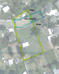
When the subdivision first came before the council it was to ask permission for the city easement to be deeded over to the developer so that there would be sufficient land to allow for build-able plats. In the course of that discussion, it came up that perhaps the city would deed over the eastern part of the easement to the Briggs so that their land was no longer cut in half. At that first meeting it was decided that the city would preliminary grant vacation of the easement pending final plat approval. There were many concerns expressed by the neighbors about flooding and the realities of developing this land. The city council basically sent it back to the developer saying that if he could come up with a way to mitigate the flooding concerns, they would allow for vacation of the city land.
That brings us to Tuesday, June 6th. The preliminary plat came before the city council but due to the death of his mother, the developer was not able to attend this meeting. As the neighbors spoke about their take on the proposal, they felt that their concerns were not resolved. The city put about $30K into this particular easement within the last year in order to help mitigate the flooding. The neighborhood concern was that with the proposal that was before the council, the work the city had done would be torn out, no compensation would be given to the city, and the original issue would start up again. Throughout the discussion the overriding feeling became that the best course of action would be to no longer vacate the lower easement to the developer but instead, finish it out as a regular cul-de-sac and have the plats stem off of this.
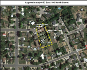
If this were to occur, three things would happen. The city work would remain in place. The Briggs would now have easy access to their eastern property. And Ms. Taylor (to the west) would not have to worry about a private drive running directly adjacent to her home. However, the developer would now have less develop-able land and with the grading of the land, it would be significantly more difficult to develop with lots running east to west instead of vice versa.
The conflict arose in the June 15th meeting because the developer brought back a proposal that looked nothing like what the neighbors had envisioned. He did take into account all of their concerns and made allowances into his proposal to try and mitigate as many of the concerns as possible.

He would keep a 30 ft easement (the same width of any flag lot driveway in the city) for the Briggs to access their property. If the easement ran too close to the existing creek, he would cut off a corner of one of the lots and deed it over to the Briggs so they could still access without having to go up the creek. He proposed a heightened retaining wall between the western private drive and the existing home. He worked a cul-de-sac into his plan to allow for easier access into the neighborhood. And he gave detailed plans about how the water mitigation would occur to prevent flooding issues from resuming. But, he made no attempt to explain why he did not create a plan in the image that the council (and neighbors) had asked. The council, developer and neighbors discussed all of this at length. The neighbors felt that their property rights were not being adequately defended and sited both the cities General Plan and City Code 17-34 regarding Planned Residential Unit Developments (PRUD). At the end of the discussion, the council voted 4-1 to approve the south-west cul-de-sac as a preliminary plat so that the developer can get started on studies to really delve into the scope of what would need to be done, beyond just theories.
I will give two final thoughts and then let this alone. The first is that I think there was a great case to be made for tabling the item until the next council meeting. This was rushed onto the agenda. There was no prior information given in the packet. The developer did not come back with any proposal that resembled what the council asked for and offered no explanation for why this was not done. My assumption (based on the developers comments about convoluted plans involving multiple cul-de-sacs) is that he misinterpreted the request and had not given consideration to the layout that was being suggested. I would have liked to see information on if the plan for an street cul-de-sac and eastern private lane would have been feasible. That being said, I do not think that the city was violating any property rights laws in moving forward with this proposal. The developer had addressed all of their original concerns. The Briggs are actually getting better access to their property (or at least unchanged) than they currently have. The development would not move forward unless engineers can definitively say that the flooding concerns are appropriately handled. There was nothing left unchecked. I think the neighbors may have pushed the council to approval by insisting that their rights were being violated. I feel fairly confident in saying that threatening legal action is the wrong way to get action from this council. They want to work with neighbors and will generally try to work through any available processes as long as everyone remains reasonable. But when solutions are offered only to have heels dig in, I think it causes these leaders to feel like continued efforts are going to continue being met with resistance. I am not making excuses for the city pushing this through but I also think it is important for people to understand that there are ways to go about things that will yield better results than threatening legal action.
This subdivision will now move forward into having studies done so that a final plat can be achieved. The final plat will, once again, go through the planning commission and city council before development begins.